The Earth Observing System Direct Broadcast System
Dr. James C. Dodge, NASA Headquarters
Washington, DC 20546
In mid-1999 NASA will begin launching the Earth Observing System (EOS) series of satellites for global environmental research studies. Each satellite which will be observing land, atmosphere, or ocean characteristics will also be transmitting those data directly to stations on the ground for purposes that require real-time information.
NOAA has had a direct broadcast (DB) system for their meteorological and environmental imaging sensors for many years. The principal change for the EOS series of satellites will be the amount of data which will be sent to ground and hence the higher transmission rate and required bandwidth. The EOS DB system will transmit on the X-band frequency of 8.2125 GHz for the EOS-AM satellite and will contain the complete Moderate-Resolution Imaging Spectoradiometer (MODIS) data stream.
The EOS-PM mission, scheduled for launch at the end of the year 2000, will transmit data from all of its Earth-viewing sensors and will provide a wealth of simultaneous information on the atmosphere and the land and ocean surfaces. The data rate for the DB system on EOS-AM will be 13.125 Mbps, and thus requires fast processing for the pseudo-random, convolutional, and Viterbi encoding that is employed. This can be done either with hardware or software or a combination of both. The details of the data encoding and reception process are beyond the scope of this article. However, Dr. Dennis Chesters from NASA's Goddard Space Flight Center (GSFC) is making all pertinent information available publicly through a Web site at:
The question of how large an antenna is required to receive EOS-DB is dependent upon the full purpose of the receiving site hardware. One could receive only EOS-DB with a relatively small dish of a little over three meters in diameter. If a reception site wishes to use the same antenna and reception hardware to receive other contemporary satellite data such as Landsat-7 or ERS for SAR data, then the antenna needs to be slightly larger, around four meters in diameter. The larger antenna is also suggested in areas where a radome is required for adverse weather protection or where reception is desired all the way to the horizon. The cost of such a system is more than the available commercial systems for NOAA's High Resolution Picture Transmission (HRPT) system. Because of this cost, it is unlikely that very many individual users will acquire EOS-DB directly. Instead, a more likely and affordable scenario is to have a few strategically-located stations for regional coverage and to share the data and derived geophysical products via the Internet. That is the approach that NASA has taken over the U.S. Currently, NASA is developing three DB ground stations for nearly complete coverage of the continental U.S. and an additional one in Hawaii to cover a wide region of the Pacific Ocean. All data and derived products are planned to be available within one hour of reception on individual Internet sites at each ground station as well as in mosaic form at the previously listed DB Web site. GSFC is also using its technology expertise to develop and test low-cost systems which eventually will make these systems more affordable commercially.
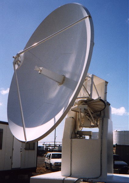
Figure 1: 5 meter EOS DB antenna at the University of Hawaii
The first EOS-DB ground station has been completed at the University of Hawaii on the island of Oahu. A photo of their five meter antenna is shown in Figure 1. It has been tested on various high-bandwidth satellite data transmissions including JERS-SAR and has been found to have very low error rates and will be adequate for all types of transmissions from Earth observing satellite for the foreseeable future. Its designer, Prof. Torben Nielsen, of the University of Hawaii can be reached on the Internet at torben@thor.Net.Hawaii.edu for additional information on this design or subsequent lower-cost designs. Additional low-cost system designs in conjunction with commercial producers has been done by Patrick Coronado of GSFC. He can be reached over the Internet at cwifs@suzieq.gsfc.nasa.gov .
The uses of an EOS Direct Broadcast reception site are many, and they vary according to the region or country deceiving the data. Current plans are focused on the capabilities of the MODIS sensor on the AM satellite, now named "Terra". The MODIS is a complex, 36-band calibrated scanning spectroradiometer, which has been designed to extend the environmental observing capabilities if the AVHRR on NOAA operational satellites. Once the full observing capability of the MODIS is achieved, through careful post-launch calibrations, satellite intercomparisons, and validations using in situ measurements; the MODIS should set the new standard for accuracy in a wide range of environmental observations. The primary uses of the MODIS observing bands are to determine land/cloud boundaries and properties, ocean color and related phytoplankton and biogeochemistry characteristics, atmospheric water vapor, land and ocean surface temperatures, and a variety of cloud characteristics, including cloud top altitude, temperature and type.
In the initial stages of operation, the EOS DB network will focus on the Earth characteristics which can be calculated quickly and have the least requirements for extended calibration before accurate results can be obtained. Some of these first products include regional ocean color and chlorophyll measurements, vegetation indices, cloud types and properties, fire locations, and storm cloud structure. Later products will include sea-surface temperatures aerosol concentrations, and land-surface temperatures requiring more refined corrections for the intervening atmosphere. An illustration of a possible type of combined real-time product for all of the DB sites is shown in Figure 2. This image was obtained from the SeaWIFS ocean color photo gallery at:
http://seawifs.gsfc.nasa.gov/SEAWIFS/IMAGES/SEAWIFS_GALLERY.html .
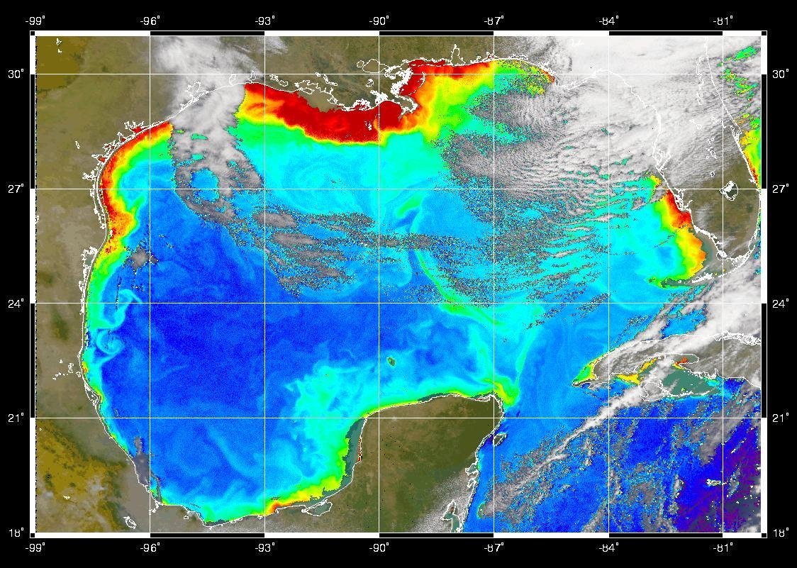
Figure 2: SEAWIFS image of the Gulf of Mexico
This is a good source to illustrate the observing capabilities of a satellite sensor designed to monitor ocean color spectral bands. The MODIS sensor on Terra will have similar capabilities. One real-time DB product that is under consideration is a combined display products that maps ocean color, vegetation index, and several cloud types along with geopolitical boundaries all on the same image, as Figure 2. suggests. The various independent DB site Internet Web pages will likely also contain the individual spectral band data and browse images from each of the 36 MODIS bands, and a number of regionally determined test products using fast algorithms suitable for creation within the one-hour period after each satellite overpass.
There is a great deal of information provided by NASA concerning the MODIS sensor, its interpretation algorithms, and its planned calibration and validation efforts. This has been provided by the EOS Project Science Office and may be found at:
Receiving the data from the satellite is only half of the process. In order to decode and process the roughly one Gigabyte of data from each full MODIS pass, it will require fast processing machines and efficient real-time algorithms to do it within the goal of one hour. With the satellite revisit time planned to be on the order of 90 minutes, product generation cannot take an extended amount of time. The various ground reception sites are each planning their own way of solving this problem. Some are developing processing systems using UNIX workstations, others are considering a network of PC's in a UNIX-controlled Beowulf configuration for high-speed parallel computation.
The results of the product generation will be placed on the individual DB Web sites and shared with a central site at the GSFC for the preparation of combined products and visualization over the entire U.S. area.
The is also considerable interest in developing or upgrading foreign ground stations in some countries to be able to receive EOS data directly. There are already preparations underway in Australia, China, Japan, Scotland, and Sweden; and there is interest in developing stations in Italy, Germany, New Zealand, Thailand, and Indonesia. Articles such as this will likely generate additional interest.
The Terra satellite is only the first is a long sequence of advanced earth-viewing satellite that will be broadcasting their data in real-time continuously for all potential users to receive it freely. The second EOS satellite observatory will be the EOS-PM satellite, scheduled for launch in December, 2000. It will have not only the MODIS that will be on Terra, but also the Advanced Microwave Scanning Radiometer (AMSR-E), the Advanced Microwave Sounder Unit (AMSU), the Atmospheric Infrared Sounder (AIRS), the Humidity Sounder for Brazil (HSB), and the sensor for Clouds and the Earth's Radiant Energy System (CERES). The data from all of these sensors will be broadcast from the EOS-PM satellite for the world to receive.
Since the types of data go beyond imaging to atmospheric temperature and moisture sounding, some of the operational meteorological agencies around the world are interested in receiving the data and seeing if its use in real-time can help to improve their weather forecasts.
Further information on the PM sensors, their data, and that DB system can be obtained from Paul Hwang of GSFC at: phwang@pop400.gsfc.nasa.gov . The characteristics of the DB system for PM are slightly different from those of Terra. The documentation of these difference has been provided on the central DB Web site listed near the beginning of this article.
Further in the future beyond these first two EOS satellites there is planned a continuation mission called the NPOESS Preparatory Mission (NPP). It, too, is planning an X-band DB system as well as the eventual converged U.S. National Polar-orbiting Operational Environmental Satellite System (NPOESS). Thus, there will be a continuing series of high-bandwidth U.S. environmental satellites over the next decade and beyond that will be delivering real-time geophysical observations and measurements to worldwide users on a free and open basis.